WELLOG
Geophysical
Considerations
Part
1, Page 1
ROCK
TYPES:
A
thorough understanding of reservoir characteristics is an important part of evaluating
oil, gas or water bearing formations. This understanding makes it possible to
understand how geophysical measurements made by the many types of logging tools
are related to reservoir parameters.
What
type of rock is a reservoir rock and what type is not?
How
do we quantify the value of a reservoir rock and the three important primary
rock parameters, porosity, permeability, and water saturation?
RESERVOIR
ROCKS:
Igneous rocks are volcanic in origin
and rarely contain oil, gas, or water.
Metamorphic rocks are sedimentary rocks
that have been recompressed through a combination of extreme heat and pressure
into solid rock material. Metamorphic rocks are not favorable reservoir rock.
Sedimentary rocks are formed through
erosion of igneous and metamorphic rocks or through organic deposition. Most
reservoir rocks are sedimentary in origin.
The
three general sedimentary rock types of importance are Sandstone, Limestone and
Dolomite.
Clastic
sediments are composed of broken and worn particles of pre-existing minerals,
rocks, and shells. These sediments are transported and eventually deposited in
successive layers.
Non-clastic
(carbonates) are characteristically Limestone or Dolomite. The rock matrix is
generally composed of once living organisms found in sea water. Fossil remains of this sea life are found in
the rock matrix.
RESERVOIR
CHARACTERISTICS:
Complete
analysis of a reservoir requires three pieces of data: porosity, permeability,
and saturation.
Porosity
is the capacity of a formation to contain fluids. By definition, porosity is
the percentage of void volume divided by the total volume.
The
symbol for porosity is the Greek symbol f.
Porosity (f) = void volume / total volume
PRIMARY
POROSITY:
Primary
porosity results from the void space between inter-granular rock fragments and
particle grains after their accumulation as sediments. The theoretical maximum
porosity based on spherical sand grains stacked on top of each-other is 46.7
percent. Primary porosity is a function of the depositional environment,
compaction, and cementation.
SECONDARY
POROSITY:
Secondary
porosity results from leaching of sediments or other actions that remove
material and form fractures, channels, caverns or vugs in a formation.
Carbonate rocks are frequently found to contain secondary porosity in the form
of vugs, solution cavities or channels.
In
general, porosity decreases with depth. As depth increases, the increasing pressure
causes compaction. The older cemented formations exhibit lower porosity. A
shallow, younger formation may have a porosity of 25 percent and an older
deeper formation may have less than 10 percent porosity.
PERMEABILITY:
Permeability
defines the ability of a reservoir to allow flow or passage of fluids.
The
symbol for permeability is the letter (K).
Permeability
is measured in darcies, a numerical expression named after the French Engineer
Henry d’ Arcy, who in 1865 devised a
method for quantifying permeability. Most
producing reservoirs have permeabilities less than 1 darcy. The permeability of rocks is measured in
millidarcies (md). Permeability may vary from 5000 md for an unconsolidated
sand to .1 md for some carbonates.
Permeability
is one darcy when 1 sq. cm of rock releases
1 cc of fluid of unit viscosity in 1 second under a pressure
differential of one atmosphere/cm.
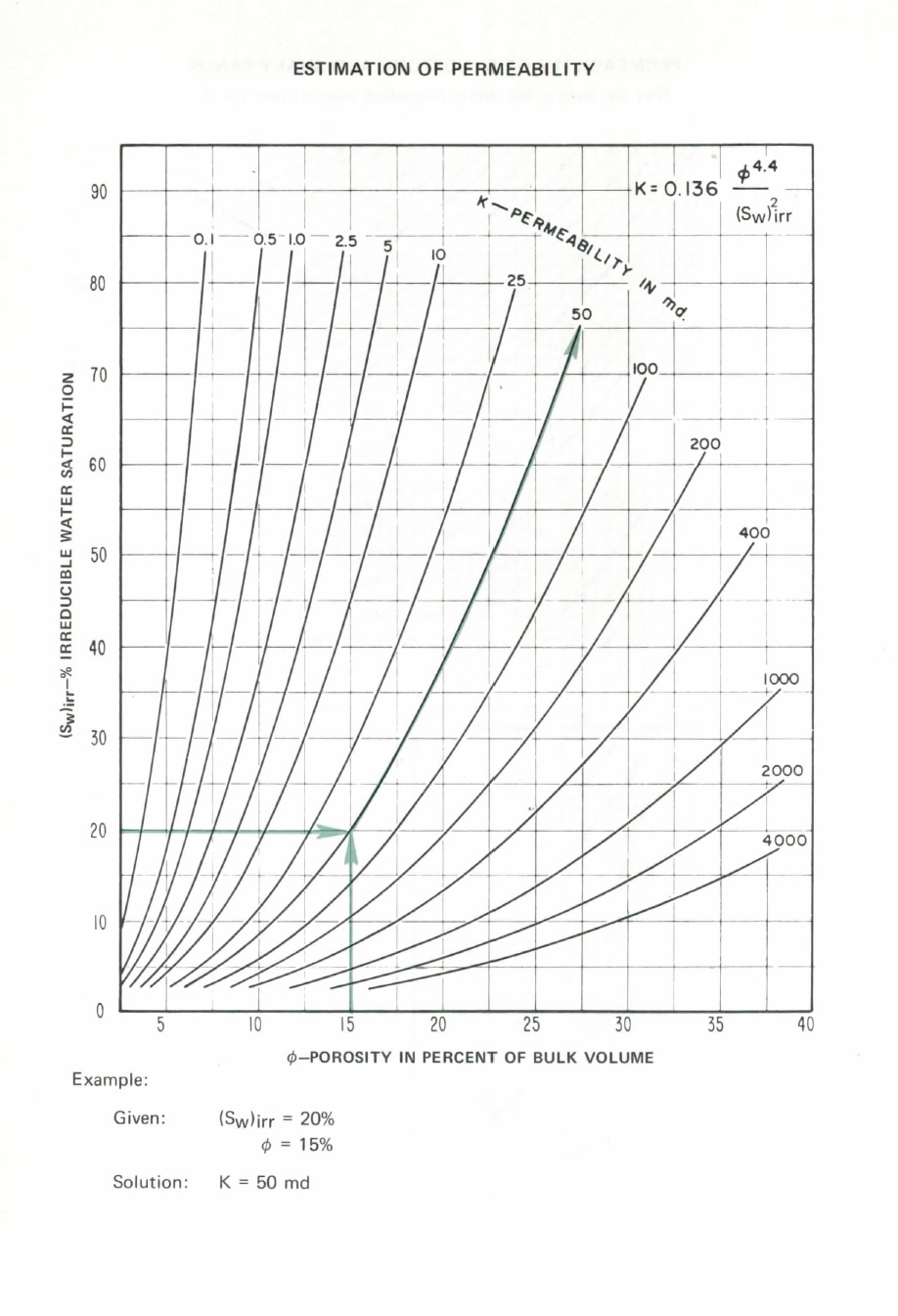
Determination
of permeability using a chart
Porosity
and permeability of selected oil sands: (Note: actual values may vary from
those given here)
Sandstone
formation: Porosity: Permeability:
Clinch,
Lee County, VA 9.6 .9
Bartlesville,
Anderson County, KS 17.5 25.0
Nugget,
Fremont County, WY 24.9 147.5
Woodbine,
Tyler County, TX 22.1 3390.0
The
rule of thumb for classifying permeability:
Excellent: > 1000 md
Very
good: 250 – 1000 md
Good: 50 – 250 md
Moderate 15 – 50 md
Poor
to fair: < 1 – 15 md
Permeability
in reservoir rocks is a directional property.
Formations exhibit both horizontal and vertical permeability. Horizontal permeability has the greatest
affect on production. The ratio of Kh to
Kv is between 1.5 and 3.0 depending on deposition, grain type, size, and shape.
Actual
permeability can be measured by core analysis.
The results depend on the testing method used for determination of
permeability. Gas and fluid permeability
are two different values. Core samples
having permeability measured under surface conditions – without the pressure of
overburden are more willing to liberate fluids. The result is permeability that
is optimistic by 25 % to 1000 %.
Permeability,
a primary rock parameter, can be indicated by but not measured directly with
logging tools which measure secondary rock parameters like resistivity and
porosity.
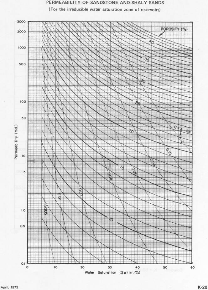
Permeability
of sandstone and shaly sands chart
Go
to our page on permeability for complete permeability interpretation.
SATURATION:
The
fluid saturation of a rock is the ratio of the volume of fluid filled porosity
to the total porosity. Fluid saturations are expressed as a percent of total
pore volume. For example, a water saturation of 20 percent means that 20
percent of the pore volume is water filled.
In a hydrocarbon reservoir, other fluids usually hydrocarbons fill the
remaining pore space.
Due
to differences in specific gravity, fluids having lower specific gravity become
segregated in ascending layers in a reservoir.
Gas will move upward until it reaches a layer of rock that is
impermeable. A formation layer of this type is referred to as a trap. Oil will
occur below the layer of gas and water will be in a layer below the oil.
Some
of the oil cannot be produced. The non-producible oil is referred to as
RESIDUAL or IRREDUCIBLE saturation. Residual hydrocarbons may be producible
using secondary recovery techniques including the use of steam or chemicals or
other methods.
The
portion of pore space that does not contain formation water is assumed to
contain hydrocarbons.
Hydrocarbons
are in the form of oil or gas.
Hydrocarbon
saturation (Sh) = 1 – Water Saturation (Sw)